Registered

The Appalachian Trail Conservancy has recently begun a voluntary registration program in hopes of nudging hikers to spread out their start dates, or to start somewhere other than one of the ends (and then “flip-flop” to complete the whole Trail). The idea is that having 25 or more hikers at each shelter for the night negatively impacts both the environment and the experience.

They’re forward-thinking on this because “A Walk in the Woods” — the Robert Redford movie coming out this Spring based on Bill Bryson’s book — will almost certainly inspire a huge number of people to hit the Trail in 2016. I’ve seen some comments online from the independently-minded hiker community about not wanting to participate in the voluntary program. I registered. Here’s what I got in the mail this week:

2015 AT thru-hike registration tag

Probably won’t hang the tag from my pack as they suggest (would make me feel like I was wearing a Minnie Pearl hat). But it’s nice to have.

Oh, and last I checked the website, there were only about a dozen registered to start hiking on 13 April. That’s about half the number that registered for the busy days in March. I’m either hiking behind the ‘bubble’ or April hikers haven’t registered yet.

Journal Entry: Test note from Evernote

Subscribers: Apologies for the repeated “This is a test of my thing to put journal notes directly into my blog.” posts.  I use a service called “Zapier” to auto-magically move entries from Evernote to the blog.  (Whenever I write a note in the “Journal” notebook in the Evernote application, it gets zapped directly into this blog. Means I don’t also have to log in to WordPress and try to fiddle with it on my phone.)

Anyway, I got a couple warning notices from Zapier that there was something wrong with my formula so, in trying to diagnose and fix the problem, I needed to send some extraneous “test” messages. Hopefully now it’ll work smoothly and you won’t be bothered by junk notices.

Footnote for technology nerds: when I set this zap up, it didn’t look like I could use IFTTT to connect Evernote and WordPress, but last night I read something that seemed to indicate I now could. If anybody knows for sure, please let me know. (And if you have no idea what I’m talking about, never mind.)

There’s an App for That!

There’s an app for that!

For hiking the Trail? Actually, yes.

I saw it mentioned in my copy of the 2015 Appalachian Trail Thru-Hiker’s Companion (in itself, an amazing annual volume that lists shelters, campsites, towns, what’s of interest in each town — all-you-can-eat buffets, post offices, hostels, grocery stores, and so on — mileage to various waypoints, elevation profiles. and so on). So I looked it up.

I was sold by the description and sample. And I’ve downloaded the app to my phone. Amazing piece of work. It’s called “Guthook’s AT Guide.”

Here’s a screenshot of the very first 4 miles of the Trail heading north from Springer Mountain, Georgia. Each red dot is a mile marker. Topographic map and all! Zoomable!

Screenshot of Springer Mountain in appAnd when I tap one of the symbols (in this case one of the water drops) there’s a notification about what that symbol is about. In this case, again, there’s a reliable water source in the form of a stream.

Screenshot of water notifiction in app

Tapping on that notification takes me to a picture of the stream (below), or shelter, or road crossing, or whatever it is. And you can see down at the bottom how far it is to the next reliable water source (which is very important information; if it’s only a mile, I don’t need to carry any water; but if it’s 12 miles, I’ll carry some, despite the weight).

Screenshot f detailed water information in appTwo other things about this app really excited me: first, I can tap the screen and it’ll show me exactly where I am. I’ve always been frustrated in the past when Ive been out hiking and can’t really tell just how many miles I’ve walked or have yet to go; wondering is the next shelter 1 mile ahead or yet 3 more miles; uncertain whether that last incline was the big hill described in the book, or is that steep climb yet to come. Now I’ll be able to tell.

And second, I will be able to link this app and its location ability to Twitter. The app will send out tweets giving my location. That’s not so important in itself except to my wife, since I have basically zero followers on Twitter. But, I have also set up an IFTTT event so that when I tweet something with the hashtag #AT2015, that tweet will automatically also come to this blog. (I really like all this technology. Probably too much.)

And, finally, to show you the northern end of the Trail where I’ll be finishing my hike, here’s an image from the app developer’s web site that shows the climb up Mt. Katahdin.

Mt. Katahdin in Guthook's AT Trail Guide website screen shot

Hiking as Pilgrimage

There are all sorts of reasons for going on a long walk. Sometimes the reason is simple. You know the old saying, “Some people look at a trailhead and path and ask ‘Why?’ I look at the same and ask ‘Why not?'”

At other times the reason is more complicated. As in heading off on a pilgrimage. Remember watching that excellent movie “The Way” starring Martin Sheen and his son Emilio Estevez, and directed by Estevez? (If you haven’t seen it yet, go find a copy and watch it soon.) The film depicts an international group of pilgrims on the Camino de Santiago in northern Spain. When I first saw it I was struck by the many similarities to the Appalachian Trail hiking experience.

And now, because of a 3 January 2015 Salon article I saw this morning before church, I mentally link the AT and the Camino with other pilgrimages around the world. The article by Joanna Rothkopf is titled “You have to go on a journey“.  Interviewing Bruce Feiler about the 6 pilgrimages he made during a year of filming the same, she elicits a lot of good commentary from Feiler. Just for example:

“I think in terms of the people who go on them, there’s a tremendous number of similarities. I would say, first of all, they are all in times of transition in their lives. … Another similarity is these pilgrimages are very difficult. The travel is hard, the food is not great, the accommodations are not wonderful and yet somehow the idea of persevering and prevailing over those difficulties becomes one of the most satisfying parts of the whole experience. … And I would say sort of a final similarity is that they are very communal. Often people go for very personal reasons but along the way they build up this community of the seeker and I think in that people find a lot of comfort and intimacy.”

Really, that could all be said about Appalachian Trail hiking. Thru-hiking the AT is a grand secular pilgrimage for a lot of people. It’s a spiritual pilgrimage for others. And for biblical Christians [and probably others] it can even be a religious pilgrimage. Or so I believe.

Hiking the Appalachian Trail . . . How Does That Work?

When Bekah was here in November she asked me “So, hiking the Appalachian Trail … how does that work?” Great question. I didn’t have a great answer. And since then — with Jenna and other family members asking similar questions about the hike — I have realized that, no, everybody else doesn’t already know all about the Trail.

In response to Bekah, I said something to the effect that “it’s like this: you walk all day; then you stop and eat something; then you sleep for a while; then you wake up and do it again. For 5 or 6 months.”

But, having thought about it for a couple weeks, I think I now have something closer to a great answer. It would be along the lines of this:

Hiking the Appalachian Trail — for me, anyway — involves careful planning for several months about how to take care of the real basics of life during the several months of that wake-up-walk-eat-sleep-repeat routine. The basics of food, clothing, shelter, and transportation. I’m working on them in reverse order as it turns out.

Transportation seems the easiest. It’s walking. All day every day (more or less). Until I’ve walked around 2,200 miles of Trail, plus a lot of extraneous miles from the Trail to a shelter and back, or to a post office or a grocery store, and other side trips like that.

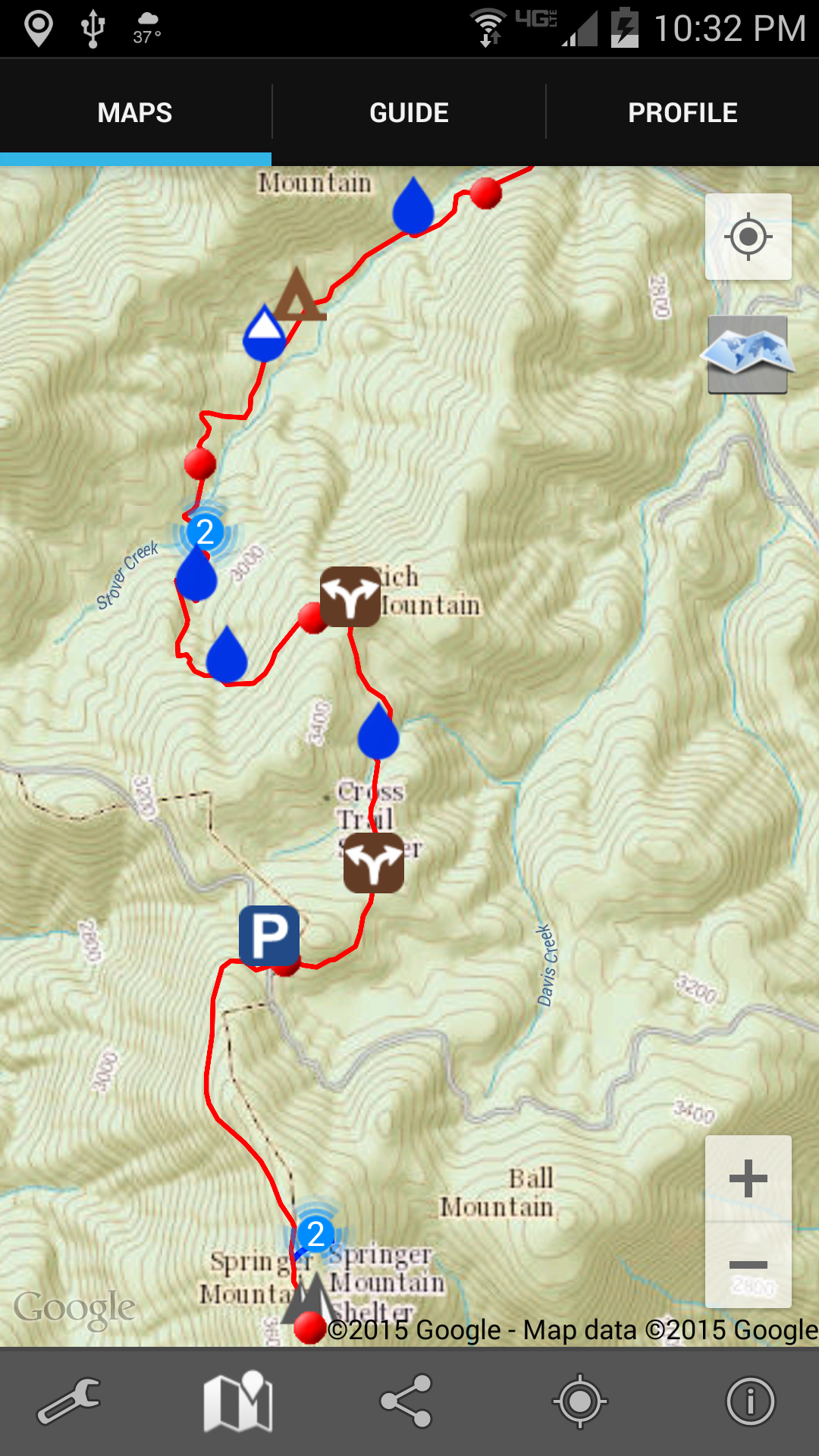
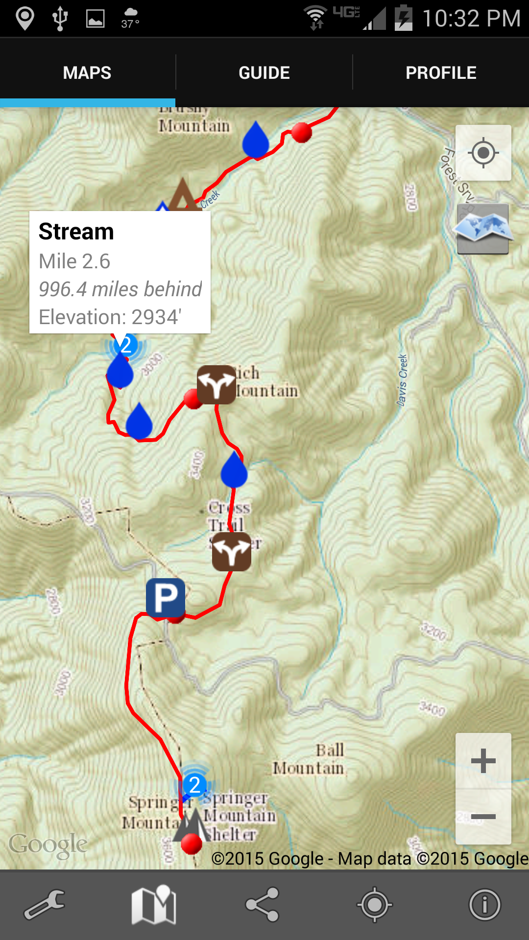
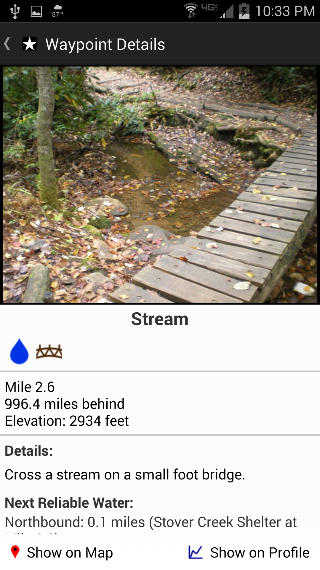
Transportation includes having decided to walk northbound (“NOBO”) from Georgia to Maine, rather than southbound (“SOBO”) or doing half of the Trail in one direction and half in the other. There are lots of detailed maps available, and several guidebooks (either for the whole Trail, or for particular parts of it). But the basic plan is to follow the white blazes that mark the Trail, show you where to turn, which fork to take when two paths diverge in the yellow woods, and so on. Two thousand miles of white paint patches, measuring 6″x2″ on trees and rocks and the occasional telephone pole in a town or wooden post in a meadow.

Transportation includes choice of footwear, too, I suppose. I haven’t narrowed things down to a particular pair of hiking shoes yet. But my plan is to be carrying a light enough load on my back that I will be able to hike in shoes and not the heavier boots I’ve worn on my earlier long distance hikes.

Shelter is a pretty easy set of decisions, too. The basic unit of shelter is usually a sleeping bag. Your choices are where you put that bag each night. There are shelters that have been constructed all along the Trail at more or less a day’s hiking distance apart. Most are a simple three-sided sort of lean-to. Some are much fancier lean-tos, with an upper floor, or skylights, or a deck, or some other feature that makes them stand out. (See elsewhere in the blog for pictures of some of the shelters I have been at before.) Probably all of them have an outhouse of some kind, as well as a spring or other water source. With a handful of exceptions the shelters are free. (And, yes, that means you regularly end up sharing space for the night with people you’ve never met before.)

Some hikers plan on sleeping in shelters most of the time. Others plan on sleeping near shelters, but in tents or hammocks or under small tarps. There are advantages to all these options. (It’s amazing just how much noise 8-12 people can make during the night what with snoring, rustling around in sleeping bags, getting up for bathroom calls, and what not. Sleeping near a shelter, rather than in it, reduces some of those drawbacks.)

My plan is to spend most nights in my hammock, but to use the shelters, too. The beauty of the hammock is that I can hang it wherever there are two trees the right distance apart; so, say I get to the shelter at 2:00 in the afternoon (which would just be too early to stop for the night, trust me). With a hammock I can keep going another few hours and stop wherever I want even if the ground’s not level enough for a tent or is rocky or wet. Just as long as I have trees.

There are also hostels along the way from time to time near where the Trail crosses a road, or perhaps in a town close to the Trail. These businesses usually provide a bunkroom, and may or may not make other amenities available — things like a shower, or laundry facilities, or meals, or an Internet connection. Naturally, hostels (and motels or bed-and-breakfasts or whatever in towns) do come at a cost.

Clothing. Ah, yes. The layered look is very much “in” on the Trail, because when you’re outdoors all day long in all sorts of weather, walking up and down mountains, you really need to be able to add warmth when you’re cold in the morning or peel off that warmth after you start sweating from the exercise or the sun.

I’m still in the midst of selecting my clothing. The thing, too, is that a backpacker wants clothes that are versatile, that work together as a system, and — maybe above all — do all that without weighing very much. You also have to deal with wearing the same clothes day after day after day. This is not the place to be if you feel you really need to be able to choose each day from amongst, say, 5 pairs of pants and 9 different shirts, several different sweaters and jackets, and a variety of matching footwear. Remember: you have to carry it all. Along with your shelter. And your food.

And food: a long distance hiker’s favorite topic. I’m figuring on being done with my clothing selection by New Year’s, and then focusing on my food for a couple months.

Overall the options for hikers are pretty open, but all boil down to finding ways to replenish the calories burned by hiking all day — while carrying your food-clothing-shelter — up and down mountains. I’ve read many places (and have no idea who did the calculation, or what it was really based on) that an Appalachian Trail thru-hiker needs something like anywhere from 3,000-6,000 calories a day to get from end to end of the Trail. Yeah, quite a range. The basic points are that it’s more than what one needs at home; and it’s (often) more than it is easy to carry.

Typical hiker trail food consists of: ramen noodles, cous-cous, or packages of Lipton noodles; maybe some beef jerky, or Slim Jims, or pepperoni, or dehydrated tuna; Snickers bars; Pop Tarts; anything with lots of carbs that — at most — requires only a small amount of boiled water to make it edible. As you probably already know or guessed, I don’t think of myself as a typical hiker on this score.

To begin with I’m a vegetarian. And for almost a year I’ve been a low carb vegetarian. Combined, these mean that most typical hiker food is off the menu.

This makes food planning more difficult and more important. Fortunately, I was able to try out a food system on a weeklong hike this summer traveling the Appalachian Trail through the length of Shenandoah National Park. I took along hard boiled eggs (two a day, and no, they don’t need to be kept in a refrigerator all the time), cheddar cheese (a quarter pound a day, and same on the refrigeration), roasted mixed nuts (a cup a day), olive oil, coconut oil, avocados, peanut butter, and one commercial dehydrated soup for dinner each night. Yes, it was heavier than a typical hiker’s food bag of 1.5 to 2 pounds of food per day. No, I probably won’t be able to buy such food along the way at every little town or gas station where hikers typically resupply. But — and I think this is key — I felt great at the end of the week. So I’m working on how to make it happen. Or deciding whether to break down and eat the carbohydrates I’ve been doing so well without.

There are towns nearby for most of the Appalachian Trail (and sometimes the Trail goes right through a town). They provide restaurants, fast food places, grocery stores, convenience stores, and post offices. All of which are food sources (well, post offices are if you have someone mail you a food box from home). These food resupply points are generally only 3-5 days apart, so it is easy for hikers to make up nutritional deficits when they hit towns, or to buy more Pop Tarts and so on at a gas station where the Trail crosses a road. Some hikers rely more on town food; some rely more on mail drops. I imagine I’ll use both, while striving to stay away from high fructose corn syrup and other processed foods or empty carbohydrates.

So that’s sort of how it works: food, clothing, shelter, and transportation. Measure (carefully), combine (wisely), stir (carefully), and serve (joyfully) with inevitable refinements along the way.

One other question I’ve been asked repeatedly: “Are you hiking alone?” The answer is, well, yes and no. I’m not planning on a hiking partner, but there are so many people hiking the Trail these days (especially near the start, before the great winnowing takes place) that it is almost certain I will be hiking at about the same pace as several other people and see them throughout the day or in the evening. So, yes, I will not be within talking distance of anyone most of the day; but I will almost always be around people at the shelters, and often they will be people I’ve met before on the Trail. (Just for example, on this past summer’s hike through the Shenandoah there was a guy from England at the same shelter I was at 5 of the 7 nights we were out.)

It’s Official

Here’s something you may not have known: the length of the Appalachian Trail changes pretty much every year.

I learned today via Facebook that the official AT distance for 2015 is 2189.2 miles. (That’s 3523.18 kilometers.) I believe the 2014 official distance was 2185.3 miles.

The additional 4 miles didn’t come from some kind of continental drift.

The thing is that there are almost always relocations, and it just seems that they always add a little distance to the whole length. For years the Trail would be moved bit by bit off of private land onto public (say, National Park Service, or Forest Service, or State Park) land. Or maybe a section just gets over-used into erosion and so the official pathway gets moved to let the original trail go into restoration mode. Or perhaps instead of aiming steeply straight up a hillside, the maintainers decide it’s time to change that climb to an easier grade by using switchbacks (zig-zagging). Or sometimes the Trail is moved to get it away from something that gets built right up on the Trail’s property line.

A couple hundred yards here, a quarter mile there … before long you’re talking 4 more miles.

Anyway, you can start the betting pools now. If a hiker starts at one end on 13 April, what day will he get to the other end now that it’s 2189.2 miles away?

Hello World!

Ah, yes, yet another Appalachian Trail blog.

The idea with this one is to document my 2015 thru-hike. I’m heading for Georgia in mid April 2015 and hope to be on Katahdin maybe as early as mid September. Still gathering gear at this point. Then will be turning my attention toward food.

I will be filling in this corner of the blogosphere meanwhile with pictures that I have take on the Trail over the last 12 or so years. And I’m experimenting with automating blog posts so that when I tag an Instagram photo with #AT2015, or when I tweet anything using that hashtag, or when I take a note in Evernote in one particular notebook, any of those actions will result in a blog post here. In short, while I may be leaving my bootprints all over the internet, you should be able to follow my trail (see what I did there?) just by checking in here regularly.