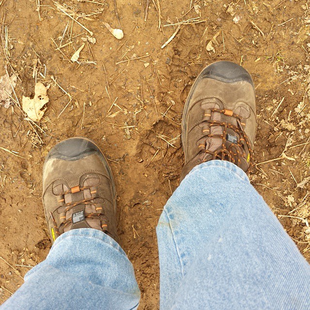
Boots’ first time on the Appalachian Trail ( in Pennsylvania today ). In 3 weeks they and I will be in Georgia. #AT2015
via Instagram http://ift.tt/1DUlAfo
via Instagram http://ift.tt/1DUlAfo
One of the long-standing traditions among A.T. thru-hikers is the use of trail names, that is, nick names, almost to the complete exclusion of real names while hiking the Trail, talking with other hikers, or writing about one’s hike.
Sometimes the names are given by other hikers. Sometimes they are self-chosen. The names seem to be inspirational or physically descriptive or literary or just plain funny. The point — I think — is to make it easier to talk with and about other hikers. Names like “Shiny Boots” or “Silver Eagle” or “Aragorn” are more memorable. They’re easier to recall than trying to remember “Now was it ‘John’ or ‘Dion’ or ‘Don’ or something else?”
Or maybe it’s escapist. People sometimes hike to get away from their other life, wanting to leave that life and all its trappings right down to their given names all behind.
One thing I know about this is that when I hiked the Long Trail in Vermont (270 miles from Canada to Massachusetts) back in 2002, I spent time throughout the month with a guy whose trail name is “Wideload.” It was given to him during an earlier A.T. hike when his pack was so wide that he couldn’t walk through a door unless he turned sideways. I have no idea what his given name is. And he surely has no idea what my given name is. At best he would remember my trail name.
My trail name is one I gave myself when I started the Long Trail hike. It was mostly based on my professional resumé at the time. I had graduated from Concordia College in NY, and Concordia Senior College in Fort Wayne, and Concordia Seminary in St. Louis; had worked at Concordia Historical Institute for 6 years; and was at the time of the hike working at Concordia College back in New York. So I chose to go by the name “Concordia.” (I always had a creative mind!)
Given the widespread lack of Latin these days this name is a little harder for people to remember out on the Trail than if I were calling myself “Moss Man” or “The Hiking Librarian.” And when people have asked about the origin of the name I have sometimes just said that it’s Latin for ‘harmony,’ which explanation seems to satisfy people. (They probably think it’s an aspirational name, that I am striving to live in harmony with nature or people or whatever.)
What I didn’t realize when I hiked the Long Trail was that there would be a lot of Canadians out hiking for whom “Concordia” meant Concordia University in nearby Montreal. Ah, well. The name did also lead to a conversation with someone who connected it to the Concordia College in Austin, TX, which is actually closer to my roots than Montreal is.
All this is a long way of saying that a month from now when I am starting my A.T. hike, I intend to sign the first and last log books with my ‘real name’* and the in between ones with my old ‘trail name’. And I am able to back up the name (and possibly help people remember it) by wearing a Concordia hat that Ann bought for me. Here are the hat and its back-up:
![20150313_072601[1]](https://kurtbodling.com/wp-content/uploads/2015/03/20150313_0726011.jpg)
*(Some of you wouldn’t know that I have for years thought of my real name as providentially pointing me towards this hike. I am Kurt A.T. Bodling. Now, the “A.T.” on my baptismal certificate doesn’t refer to the “Appalachian Trail,” but still . . . . )
Six weeks doesn’t seem like a very long time yet to go.
I have a lot of little details yet to wrap up before I’m ready to hit the Trail. Like pulling together a first aid kit. Or getting a really small toothpaste tube to take along. Or nailing down just where I think I might “re-supply” (that is, get the next few days’ worth of food either by mail or at a grocery store).
That last one is actually not a little detail.
Lots of people hike this Trail with little or no planning. At least they start that way. I don’t know what the stats are on whether detailed planners are more likely to finish the whole hike. But I do believe that the flexible schedulers are more likely to. And by nature I’m a scheduler.
So, for example, I have been trying to chart out how far I think I will get by this or that date, in order to be able to tell family and friends when I will be in their region. My approach, of course, is to go to the books. I pulled some of the hiker narratives off my shelves and built a spreadsheet of where they were when, adjusting their start date to match mine. Did that with 4 different hikers. Turns out they took widely varying amounts of time to complete their hikes: from 111 days to 147 days.
Then I came across a chart of post offices one hiker used, with the days he was able to get to each one. Great spreadsheet, too, because it also showed how many miles between these food drops, how many days of meals each box needed to contain, and how many miles per day it would take to get to that post office. Best part for me is that after charting it out, I saw he took 152 days, which is about what I’ve been thinking I will be aiming for: just about 5 months, but leaving myself a month of leeway. Excellent!
Then this guy’s spreadsheet also had a formula in it to recalculate the days and dates for each stop, based on start date. I changed the date to 13 April, and voila!, there are the dates I might be at those locations.
Now the flexibility part: fully one third of the calculated target dates are on Sundays. And post offices aren’t open on Sundays (a lot of these small post offices don’t have much in the way of Saturday hours, either). So be flexible: a) hike faster or slower in order to start hitting the post offices during the week; b) switch to other options like having packages sent to hostels or other hiker-friendly businesses; c) aim to resupply more at grocery stores than through the mail; d) make whatever adjustments it takes.
I have to, in other words, schedule in some spontaneity!
And I have 6 weeks from today to do it.
The Appalachian Trail Conservancy has recently begun a voluntary registration program in hopes of nudging hikers to spread out their start dates, or to start somewhere other than one of the ends (and then “flip-flop” to complete the whole Trail). The idea is that having 25 or more hikers at each shelter for the night negatively impacts both the environment and the experience.
They’re forward-thinking on this because “A Walk in the Woods” — the Robert Redford movie coming out this Spring based on Bill Bryson’s book — will almost certainly inspire a huge number of people to hit the Trail in 2016. I’ve seen some comments online from the independently-minded hiker community about not wanting to participate in the voluntary program. I registered. Here’s what I got in the mail this week:
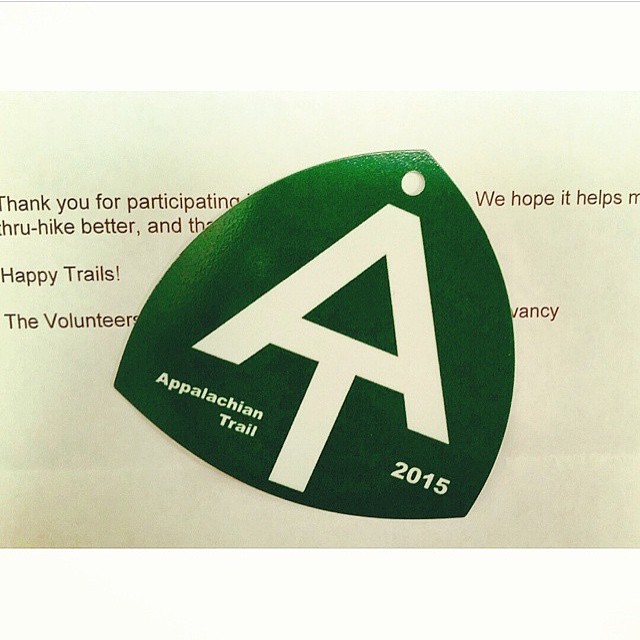
Probably won’t hang the tag from my pack as they suggest (would make me feel like I was wearing a Minnie Pearl hat). But it’s nice to have.
Oh, and last I checked the website, there were only about a dozen registered to start hiking on 13 April. That’s about half the number that registered for the busy days in March. I’m either hiking behind the ‘bubble’ or April hikers haven’t registered yet.
2 months from today I head out on the adventure of a lifetime: #AT2015 my Appalachian Trail thru hike
from http://ift.tt/1KS9SSX via IFTTT
There’s an app for that!
For hiking the Trail? Actually, yes.
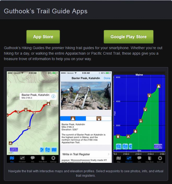
I saw it mentioned in my copy of the 2015 Appalachian Trail Thru-Hiker’s Companion (in itself, an amazing annual volume that lists shelters, campsites, towns, what’s of interest in each town — all-you-can-eat buffets, post offices, hostels, grocery stores, and so on — mileage to various waypoints, elevation profiles. and so on). So I looked it up.
I was sold by the description and sample. And I’ve downloaded the app to my phone. Amazing piece of work. It’s called “Guthook’s AT Guide.”
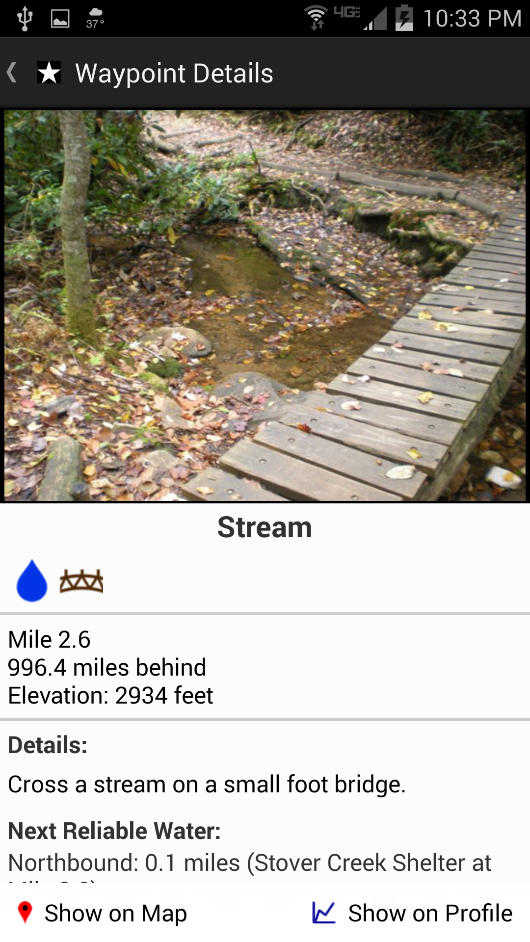
Here’s a screenshot of the very first 4 miles of the Trail heading north from Springer Mountain, Georgia. Each red dot is a mile marker. Topographic map and all! Zoomable!
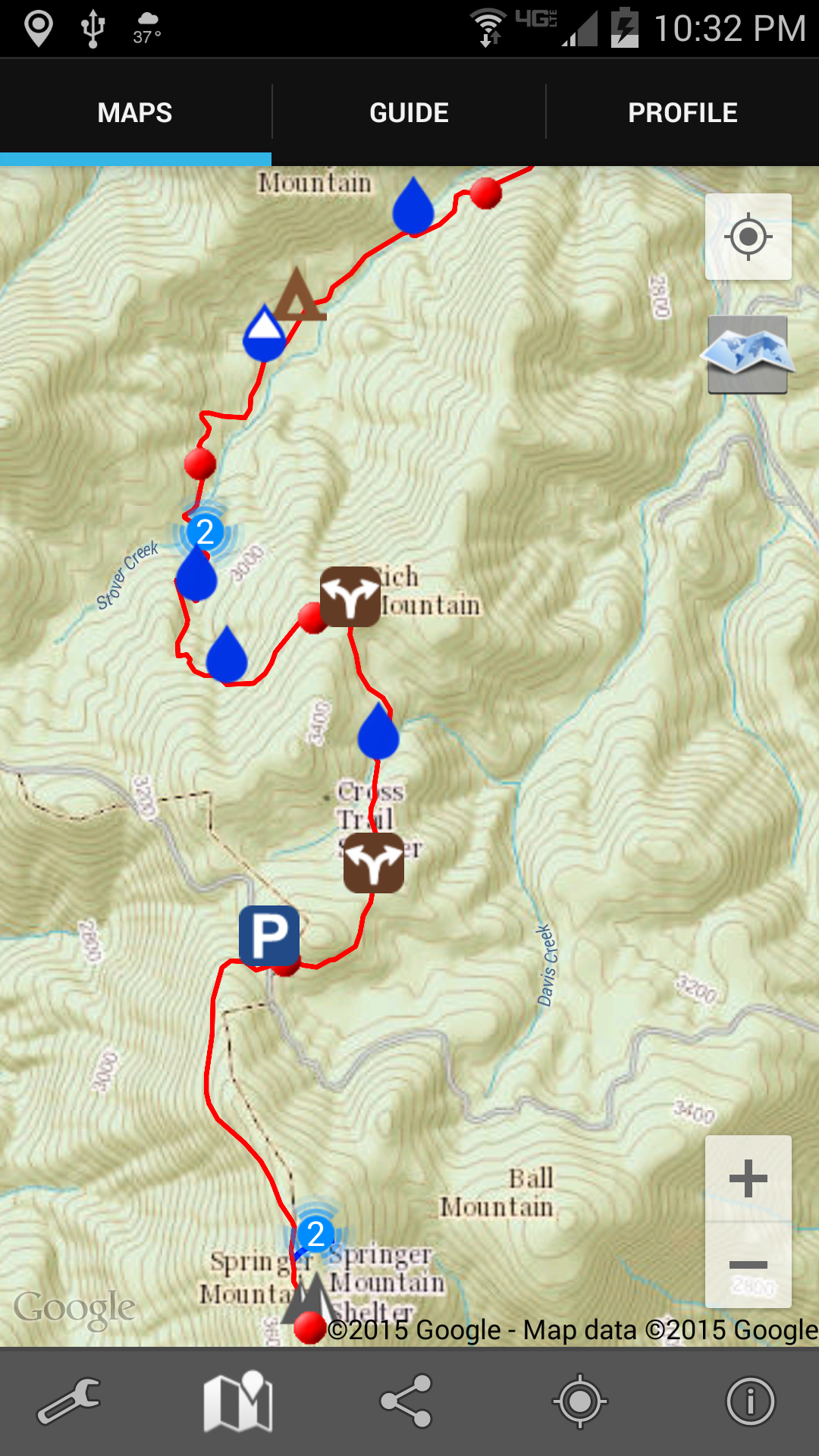 And when I tap one of the symbols (in this case one of the water drops) there’s a notification about what that symbol is about. In this case, again, there’s a reliable water source in the form of a stream.
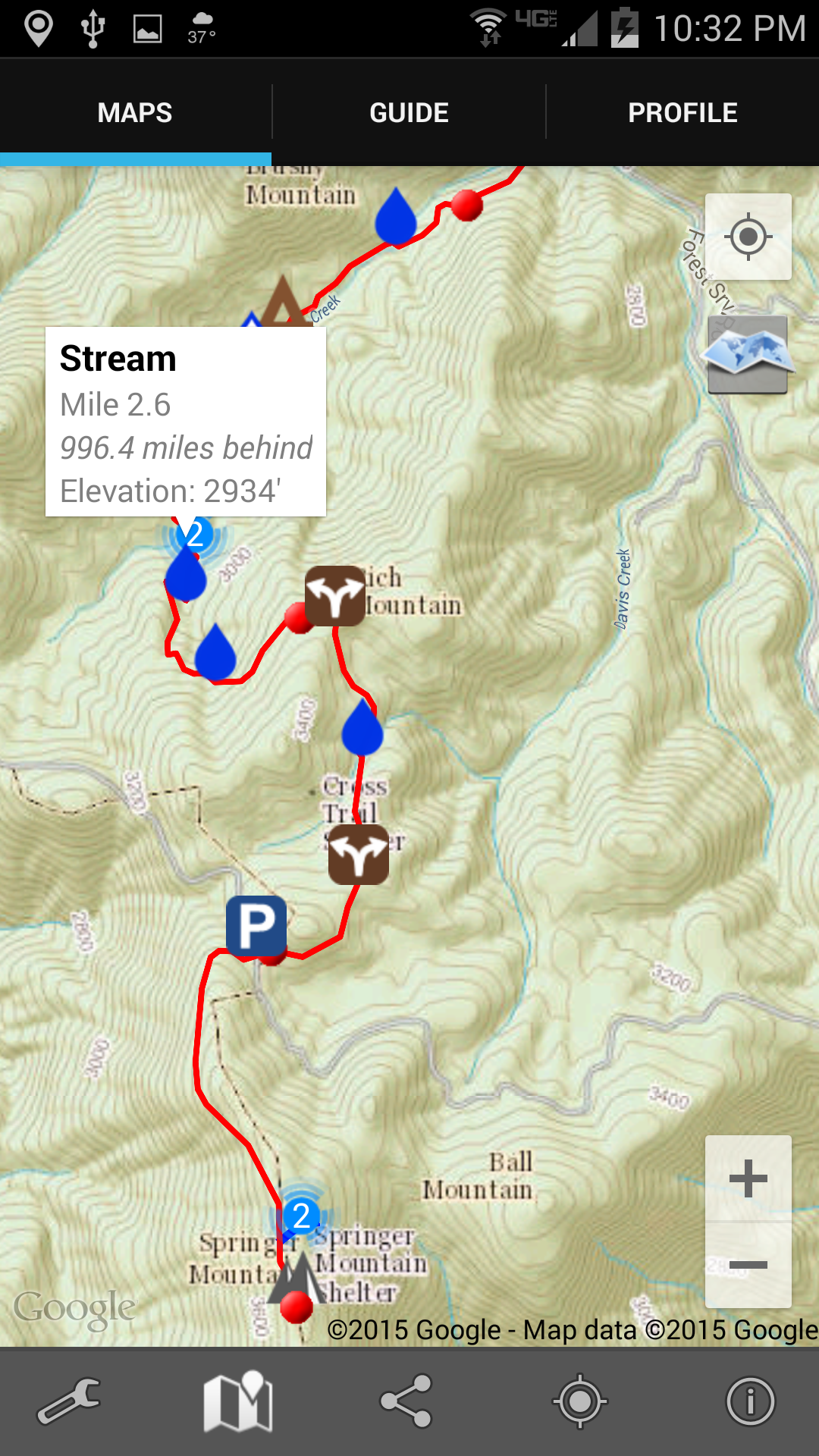
Tapping on that notification takes me to a picture of the stream (below), or shelter, or road crossing, or whatever it is. And you can see down at the bottom how far it is to the next reliable water source (which is very important information; if it’s only a mile, I don’t need to carry any water; but if it’s 12 miles, I’ll carry some, despite the weight).
 Two other things about this app really excited me: first, I can tap the screen and it’ll show me exactly where I am. I’ve always been frustrated in the past when Ive been out hiking and can’t really tell just how many miles I’ve walked or have yet to go; wondering is the next shelter 1 mile ahead or yet 3 more miles; uncertain whether that last incline was the big hill described in the book, or is that steep climb yet to come. Now I’ll be able to tell.
And second, I will be able to link this app and its location ability to Twitter. The app will send out tweets giving my location. That’s not so important in itself except to my wife, since I have basically zero followers on Twitter. But, I have also set up an IFTTT event so that when I tweet something with the hashtag #AT2015, that tweet will automatically also come to this blog. (I really like all this technology. Probably too much.)
And, finally, to show you the northern end of the Trail where I’ll be finishing my hike, here’s an image from the app developer’s web site that shows the climb up Mt. Katahdin.
In three months from tonight I’ll be trying to get to sleep on a mountain in north Georgia.
There is a LOT of planning and preparation left to do, but I know the intervening time will fly by.

There are all sorts of reasons for going on a long walk. Sometimes the reason is simple. You know the old saying, “Some people look at a trailhead and path and ask ‘Why?’ I look at the same and ask ‘Why not?'”
At other times the reason is more complicated. As in heading off on a pilgrimage. Remember watching that excellent movie “The Way” starring Martin Sheen and his son Emilio Estevez, and directed by Estevez? (If you haven’t seen it yet, go find a copy and watch it soon.) The film depicts an international group of pilgrims on the Camino de Santiago in northern Spain. When I first saw it I was struck by the many similarities to the Appalachian Trail hiking experience.
And now, because of a 3 January 2015 Salon article I saw this morning before church, I mentally link the AT and the Camino with other pilgrimages around the world. The article by Joanna Rothkopf is titled “You have to go on a journey“. Interviewing Bruce Feiler about the 6 pilgrimages he made during a year of filming the same, she elicits a lot of good commentary from Feiler. Just for example:
“I think in terms of the people who go on them, there’s a tremendous number of similarities. I would say, first of all, they are all in times of transition in their lives. … Another similarity is these pilgrimages are very difficult. The travel is hard, the food is not great, the accommodations are not wonderful and yet somehow the idea of persevering and prevailing over those difficulties becomes one of the most satisfying parts of the whole experience. … And I would say sort of a final similarity is that they are very communal. Often people go for very personal reasons but along the way they build up this community of the seeker and I think in that people find a lot of comfort and intimacy.”
Really, that could all be said about Appalachian Trail hiking. Thru-hiking the AT is a grand secular pilgrimage for a lot of people. It’s a spiritual pilgrimage for others. And for biblical Christians [and probably others] it can even be a religious pilgrimage. Or so I believe.
It is a commonplace that the Appalachian Trail is called “the long green tunnel” because so much of its footpath runs under the trees. There are places, however, where hikers hike out in the sun.
Think of the White Mountains in New Hampshire, for example. Up above the treeline. In the sun … and wind … and rain … and snow.
There’s also the area just above Palmerton, Pennsylvania. I took these 2 pictures there on 31 May 2005:
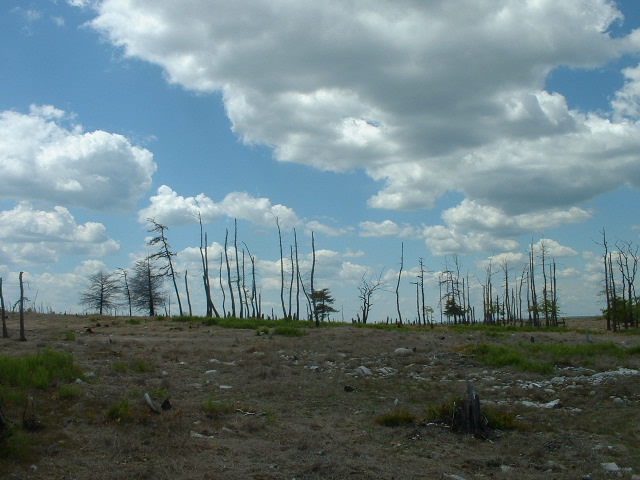
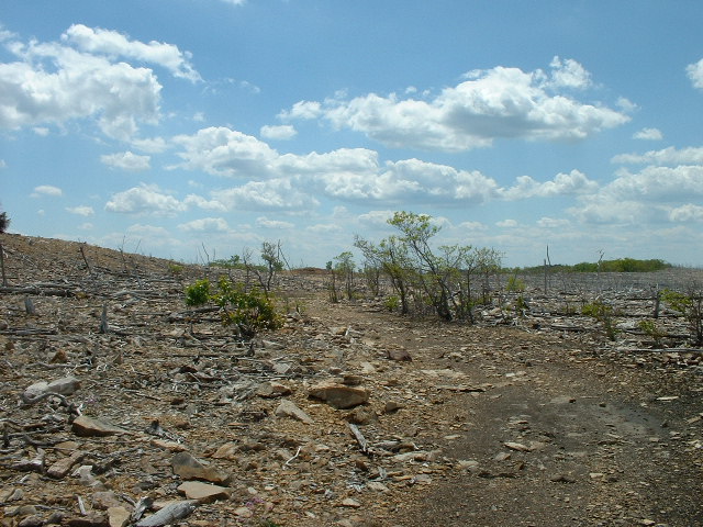 Why so bleak? Because this EPA Superfund Site is still recovering from decades of zinc processing that took place there. The EPA web site contains this description:
The Palmerton Zinc Pile Site is the area of a former primary zinc smelting operation. The site encompasses the Bourough of Palmerton and surrounding areas, Blue Mountain, a large smelting residue pile called the Cinder Bank and much of the valley. For nearly 70 years, the New Jersey Zinc Company depositied 33 million tons of slag at the site, creating a cinder bank that extends for 2 ½ miles and measures over 100 feet high and 500 to 1,000 feet wide. The smelting operations emitted huge quantities of heavy metals throughout the valley. As a result, approximately 2,000 acres on Blue Mountain, which is adjacent to the former smelters, have been defoliated, leaving a barren mountain side. Soil on the defoliated area of the mountain has contaminated the rain water flowing across it. The runoff and erosion have carried contaminants into Aquashicola Creek and the Lehigh River. Approximately 850 people live within one mile of the site; the population of the town of Palmerton is approximately 5,000. The Palmerton Water Company has four production wells at the foot of Blue Mountain that supply water to the towns of Palmerton and Aquashicola, these wells have not been effected by contaminants from the site to date.
The pictured area is on top of Blue Mountain, where
In April 2006 EPA approved a second preliminary design for revegetation of over 450 acres of privately owned land. Work to apply amendments, fertilizer, lime and warm season grasses to over 200 acres via agricultural tractor and spreader and an additional approx. 200 acres via fixed wing crop-duster type aircraft was completed in September 2006. Aerial Application of lime fertilizer and seed occurred in March 2011 via fixed wing crop-duster type aircraft on approx. 1500 acres of PA Game Commission and National Park Service . Aerial application was completed on an additional 128 acres in March 2012. In 2013 the installation of over 70 acres of resources islands was completed by contractors for CBS Corporation. The five resource islands are fence enclosed areas where tree seeds and seedlings have been planted and will be intensively maintained in an attempt to foster the growth of the trees to provide an ongoing seed source for the rest of the mountain. A total of over 13,000 trees of various variety including hybrid American Chestnut were planted in the resource islands. The revegetation, resource island construction and tree planting was completed in September 2013. Monitoring of the success of the revegetation and tree plant will continue along with management of invasive species. (source for both quotes: http://www.epa.gov/reg3hscd/npl/PAD002395887.htm)
I’ll be sure to let you know whether I notice any difference in the vegetation after I get there.
Fun fact about Palmerton: the city allows hikers to spend the night in the basement of the borough hall for free … you just have to check in with the police when you arrive.
