It is a commonplace that the Appalachian Trail is called “the long green tunnel” because so much of its footpath runs under the trees. There are places, however, where hikers hike out in the sun.
Think of the White Mountains in New Hampshire, for example. Up above the treeline. In the sun … and wind … and rain … and snow.
There’s also the area just above Palmerton, Pennsylvania. I took these 2 pictures there on 31 May 2005:
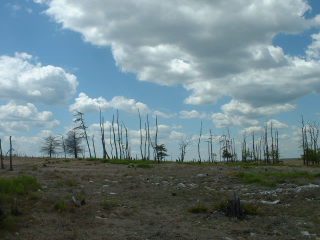
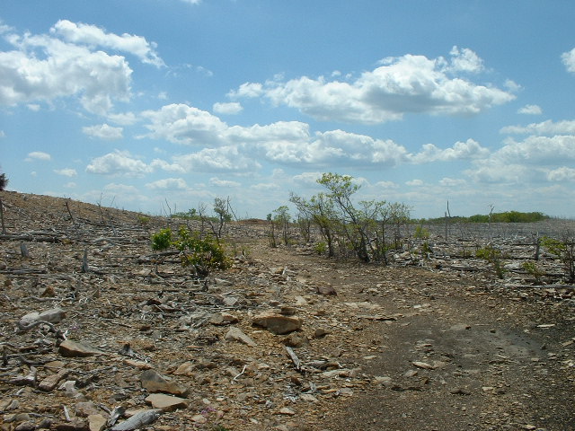 Why so bleak? Because this EPA Superfund Site is still recovering from decades of zinc processing that took place there. The EPA web site contains this description:
The Palmerton Zinc Pile Site is the area of a former primary zinc smelting operation. The site encompasses the Bourough of Palmerton and surrounding areas, Blue Mountain, a large smelting residue pile called the Cinder Bank and much of the valley. For nearly 70 years, the New Jersey Zinc Company depositied 33 million tons of slag at the site, creating a cinder bank that extends for 2 ½ miles and measures over 100 feet high and 500 to 1,000 feet wide. The smelting operations emitted huge quantities of heavy metals throughout the valley. As a result, approximately 2,000 acres on Blue Mountain, which is adjacent to the former smelters, have been defoliated, leaving a barren mountain side. Soil on the defoliated area of the mountain has contaminated the rain water flowing across it. The runoff and erosion have carried contaminants into Aquashicola Creek and the Lehigh River. Approximately 850 people live within one mile of the site; the population of the town of Palmerton is approximately 5,000. The Palmerton Water Company has four production wells at the foot of Blue Mountain that supply water to the towns of Palmerton and Aquashicola, these wells have not been effected by contaminants from the site to date.
The pictured area is on top of Blue Mountain, where
In April 2006 EPA approved a second preliminary design for revegetation of over 450 acres of privately owned land. Work to apply amendments, fertilizer, lime and warm season grasses to over 200 acres via agricultural tractor and spreader and an additional approx. 200 acres via fixed wing crop-duster type aircraft was completed in September 2006. Aerial Application of lime fertilizer and seed occurred in March 2011 via fixed wing crop-duster type aircraft on approx. 1500 acres of PA Game Commission and National Park Service . Aerial application was completed on an additional 128 acres in March 2012. In 2013 the installation of over 70 acres of resources islands was completed by contractors for CBS Corporation. The five resource islands are fence enclosed areas where tree seeds and seedlings have been planted and will be intensively maintained in an attempt to foster the growth of the trees to provide an ongoing seed source for the rest of the mountain. A total of over 13,000 trees of various variety including hybrid American Chestnut were planted in the resource islands. The revegetation, resource island construction and tree planting was completed in September 2013. Monitoring of the success of the revegetation and tree plant will continue along with management of invasive species. (source for both quotes: http://www.epa.gov/reg3hscd/npl/PAD002395887.htm)
I’ll be sure to let you know whether I notice any difference in the vegetation after I get there.
Fun fact about Palmerton: the city allows hikers to spend the night in the basement of the borough hall for free … you just have to check in with the police when you arrive.

Didn’t you say that most of PA is pretty drab on the Trail?
LikeLike
It’s pretty rocky (hikers derisively call it “Rocksylvania”), but I wouldn’t say drab. Most of the Trail through PA is wooded; some runs through farmland — as in stretch your arms out to the side and you’ll touch corn growing in the field; there are state parks and state gamelands; ups, downs, flat places and vistas.
LikeLike